Introduction

A national Census of the population across England and Wales was held in March 2021, managed by the Office for National Statistics (ONS). This provides an up-to-date count of the resident population and its characteristics.
Results for very local areas have recently become available from ONS or can be calculated, including some results for civil parishes. These contain less detail than results made available for larger areas, to avoid any risk of identifying individuals at a very local level. Despite this limitation, useful statistics about topics such as population, employment, housing and health are now available, and a selection are covered by this document.
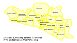
Statistics have been selected which should help with understanding key features of the area, such as the number of older residents, the proportion engaged in employment, the extent of part-time employment, formal qualifications held, the numbers in social and private rented housing, the level of car ownership and the prevalence or poor health. Statistics are presented, here, to enable comparison between BLAP parish councils (of which there are fourteen) and with the overall picture for Dorset or for England.
It should be noted that ONS base their statistics on so-called Census ‘output areas’, which are the smallest unit for which they will release data. Boundaries of output areas are sometimes slightly different to parish boundaries, so parish statistics are technically a best fit. Typically, any differences are very small. However, the use of output areas means ONS combine Catherston Lewiston with Charmouth and combine Stanton St Gabriel with Chideock (although it is part of the Char Valley group parish council).
If any Parish Councils wish to explore the available 2021 Census data further, they can do so using the ONS ‘Build a custom area profile’ tool and ONS NOMIS website, though some prior understanding of Census data and ONS websites is certainly helpful, especially with NOMIS.
